

Folia iowa, iowa na folii samoprzylepnej
FILTRUJ WYNIKI
Orientacja obrazów: wszystkie
pozioma
pionowa
kwadratowa
Rodzaj obrazów: wszystkie
zdjęcie
ilustracja
wektor
Zastosuj
#528259552
 Aerial View of Cedar Rapids Downtown Skyline
#756018831
 beautiful sunset over an Iowa barn
#435947238
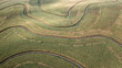
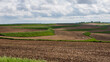 Contour farming in rural Iowa along the Loess Hills National Scenic Byway
#697282926
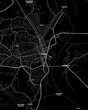 Dubuque Iowa Map, Detailed Dark Map of Dubuque Iowa
#465292291
 Iowa State Capitol
#344997459
 Aerial view of the Iowa State Capitol Building at Sunset with the Downtown Skyline Behind
#404090280
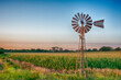 Vintage windmill at sunset with cornfield.
#463464851
 A setting sun highlights harvest ready corn plants.
#621332883
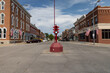 Antique stoplight in downtown Toledo, Iowa.
#197971503
 Des Moines Iowa skyline in USA
#734944343
 farming iowa corn field
#721501700
 Grill Pork Chops steaks realistic 3d UHD Wallpaper
#740371865
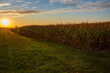
 Taken from a drone at sunset the corn field shows all its beauty with golden hour tones.
#519466262
 Aerial View of the Des Moine, Iowa Skyline facing West
#757707220
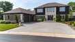 smooth concrete driveway in des moines iowa
#8596127
 Iowa Road Sign
#729549602
 Adair County, Iowa. Outline of the map
#696073161
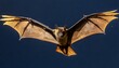 big brown bat eptesicus fuscus flying iowa usa
#537952386
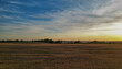
 The Iowa countryside is more beautiful than imaginable.
#678579487
 An incredible day outdoors
#497610881
 Sioux City Iowa City Hall Building Aerial View of Downtown Area and Missouri River
#768193681
 The sun is setting, casting a warm glow over the calm body of water in Burlington, Iowa.
#769579059
 Close-up of person putting on letters with flag Iowa in mailbox
#697282977
 West Des Moines Iowa Map, Detailed Dark Map of West Des Moines Iowa
#343779426
 Iowa. Corn field
#487649257
 View of the Iowa State Capitol Building in Des Moines, Iowa, at sunset.
#782531793
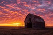
 Red Farm Barn at Sunset
#235004449
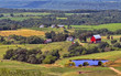 Family farms dot the landscape of northeaastern Iowa.
#434482006
 Iowa State Capitol Building Downtown Des Moines Aerial Night Long Exposure Photo Drone
#262145909
 Old Capitol building downtown Iowa City
#734362271
 crop iowa corn field
#509146232
 The Iowa state flag waving along with the national flag of the United States of America
dodaj do ulubionych