

Folia iowa, iowa na folii samoprzylepnej
FILTRUJ WYNIKI
Orientacja obrazów: wszystkie
pozioma
pionowa
kwadratowa
Rodzaj obrazów: wszystkie
zdjęcie
ilustracja
wektor
Zastosuj
#349009148
 Iowa Map Black | State Border | United States | US America | Transparent Isolated | Variations
#240262857
 Des Moines, Iowa City Skyline at SUnset
#367657856
 Horseshoe Bend State Park in Iowa in the Summer of 2020
#254006486
 Iowa state of United States flag waving on the top sunrise mist fog
#104167925
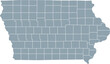
 Iowa black map on white background vector
#197971722
 Des Moines Iowa skyline in USA
#649835311
 field iowa cornfields agricultural illustration corn rural, landscape agriculture, sky green field...
#319921485
 Aerial of Downtown Des Moines at Sunrise
#472284702
 Des Moines Papa John Sculpture Park Aerial
#735231351
 harvest corn field iowa
#600290680
 Black line icon for iowa usa
#494953516
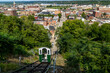 View of fenelon place elevator on a sunny day in Dubuque city, Iowa, United States
#51514469
 iowa
iowa
#316416701
 A hot air balloon floats above an Iowa rural landscape.
#21934228
 IOWA CORN
#435944774
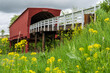 Roseman Covered Bridge near Winterset, Madison County, along the Covered Bridges Scenic Byway, Iowa
#225113883
 Mason City Iowa East Park
#762978187
 smooth concrete driveway in des moines iowa
#290951899
 black outline of Iowa map- vector illustration
#384878583
 Bike trail Iowa
#338775229
 Iowa Map Black | State Border | United States | US America | Transparent Isolated | Variations
#733496949
 Cedar Rapids Iowa Map, Detailed Map of Cedar Rapids Iowa
#73193202
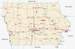 iowa road map
#718662127
 doodle freehand drawing of iowa state map.
#113617817
 Iowa written on the road
#197971423
 Des Moines Iowa skyline in USA
#768237352
 The silhouette of a person riding a skateboard with orange wheels at sunset at University of...
#320140769
 Aerial View of the Des Moines River and Skyline at Night
#354212247
 Aerial View of Downtown Council Bluffs, Iowa
#734492770
 farming iowa corn field
#89298176
 Centennial Bridge across the Mississippi River at dusk between Rock Island, Illinois and Davenport,...
#509033761
 scenic views around des moines iowa city downtown
dodaj do ulubionych