

Szkło geodezja, geodezja płytki szklane, panel szklany geodezja, geodezja na szkle
FILTRUJ WYNIKI
Orientacja obrazów: wszystkie
pozioma
pionowa
kwadratowa
Rodzaj obrazów: wszystkie
zdjęcie
ilustracja
wektor
Zastosuj
#268869272
 engineer site survey with laser tripod machine in site construction background
#540463599
 Surveyor engineer stands at the geodetic instrument. Geodetic and cadastral works
#157114730
 Surveyor’s telescope at new road construction site
#302757584
 Surveyor engineer with equipment (theodolite or total positioning station) on the construction site...
#600398131
 Satellite above earth. Topographic surveys from space. Satellite geodetic research. Creation of...
#79727247
 surveyor equipment theodolie outdoors
#59342137
 Surveyor engineer making measure on the field
#393551419
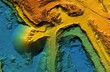 Digital elevation model. GIS product made after proccesing aerial pictures. It shows excavation site...
#41468396
 engineering instrument and construction industry
#578388395
 Topographic map background geographic line map with elevation assignments. Modern design with White...
#378798094
 Construction Worker Using Theodolite Surveying Optical Instrument for Measuring Angles in Horizontal...
#143445353
 Important surveying on the construction site the foreman
#709850177
 survey engineer in construction site use theodolite mark a concrete pile co ordinate
#135311126
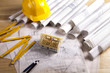
 image of the architectural project engineer. Vintage tone and engineering tools in the workplace.
#100544269
 silhouette black man survey and civil engineer stand on ground w
#668858086
 The space satellite collects data for reconnaissance. Visualization of a satellite against the...
#449359409
 Surveying or land surveying is the technique, profession, art, and science of determining the...
#460797509
 Imaginary cadastral map of territory with buildings and roads drawn with a CAD...
#259413477
 Surveyor on green field
#27725839
 Theodolite measurement instrument outdoors
#179704423
 Picture of construction engineer working on building site
#177115452
 Geodesy symbol for surveyor vector
#37078355
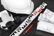
 Architecture plans
#429401865
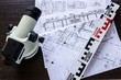
 Prace geodezyjne i narzędzia pracy geodety: kask, mapa, teodolit, taśma miernicza
#446939315
 Surveyor with a tripod. Man surveyor on orange background. Man with optical level. Theodolite in...
#55375289
 surveyor equipment theodolite at construction site
#179361878
 Surveyor builder Engineer with theodolite transit equipment at construction site outdoors during...
#721639872
 Digital elevation model. GIS product made after proccesing aerial pictures. It shows excavation site...
#306406152
 Selective focus of surveyor with blueprint and colleague using digital level on construction site
#201769740
 Mountain hiking. Map line of topography. Vector abstract topographic map concept with space for your...
#682218191
 Topographic map background illustration of island hand drawn. Contour background design element thin...
#143445979
 Important surveying on the construction site the foreman
dodaj do ulubionych