

Zdjęcia na PCV autora drhfoto
FILTRUJ WYNIKI
Orientacja obrazów: wszystkie
pozioma
pionowa
kwadratowa
Rodzaj obrazów: wszystkie
zdjęcie
ilustracja
wektor
Zastosuj
#795309844
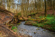 Footpath besides Letah Burn, in Letah Wood a rural ancient woodland through which Letah Burn runs,...
#795309230
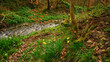 Letah Woods Wild Daffodils, a rural ancient woodland through which Letah Burn runs, near Hexham in...
#795308956
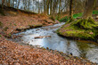 Letah Burn in Letah Wood, a rural ancient woodland through which Letah Burn runs, near Hexham in...
#795308303
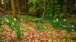 Daffodils in Target Wood, a rural ancient woodland through which Birkey Burn runs, near Hexham in...
#795307777
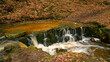 Lower Falls of Birkey Burn, in Target Wood a rural ancient woodland through which Birkey Burn runs,...
#795307446
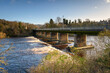
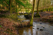 Footbridge over Birkey Burn in Target Wood, a rural ancient woodland through which Birkey Burn runs,...
#795306402
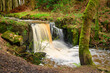 Birkey Burn Waterfall in Target Wood, a rural ancient woodland through which Birkey Burn runs, near...
#795307008
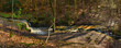 Panorama of Falls in Birkey Burn, at Target Wood a rural ancient woodland through which Birkey Burn...
#617016479
 Barrowburn Hay Meadows looking up Coquetdale. The upland Hay Meadows of Northumberland National...
#763146041
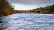
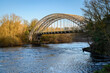
 Hagg Bank old railway bridge at Wylam. The Hagg Bank Bridge at Wylam now a pedestrian Bridge spans...
#763147532
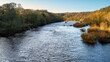
 River Tyne upstream of Wylam Road Bridge. The River Tyne at Wylam located in Northumberland on the...
#763147438
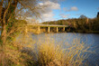
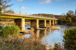
 Wylam Road Bridge above River Tyne. The River Tyne at Wylam located in Northumberland on the...
#763147231
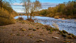
 Tree-Lined River Tyne at Wylam. The River Tyne at Wylam located in Northumberland on the tree-lined...
#763146975
 River Tyne flows below Wylam Bridge. The River Tyne at Wylam located in Northumberland on the...
#763146637
 Riverside View of River Tyne at Wylam, located in Northumberland on the tree-lined riverbanks of the...
#763146121
 The River Tyne at Wylam from Hagg Bank Bridge, at Wylam now a pedestrian Bridge spans the River...
#763145458
 River Tyne flows below Hagg Bank Bridge, at Wylam now a pedestrian Bridge spanning the River Tyne in...
#763145340
 The Sun Sets beyond Hagg Bank Bridge, at Wylam now a pedestrian Bridge spans the River Tyne in...
#774041870
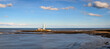
 St Mary's Lighthouse in the North Sea, on the small rocky St Mary's Island, just north of Whitley...
#774041771
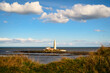
 Panorama of St Mary's Lighthouse, on the small rocky St Mary's Island, just north of Whitley Bay on...
#774041727
 Daffodils above St Mary's Lighthouse, on the small rocky St Mary's Island, just north of Whitley Bay...
#774041210
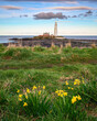
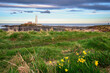 Springtime Daffodils at St Mary's Lighthouse, on the small rocky St Mary's Island, just north of...
#460316140
 Green Rigg Wind Farm Panorama, which is an 18 turbine onshore Wind Farm located near Sweethope...
#573962725
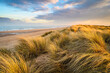 Golden Light on Marram Grass in Druridge Bay, located on the North Sea in Northumberland's AONB in...
#729409343
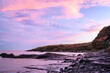 Pink Clouds over Howick Coastline, on the rocky shoreline at Howick on the Northumberland coast,...
#87522906
 Modern Sunroom external
#80960330
 Sun Room
#763146548
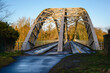
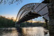
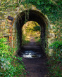 Arched Walkway next to Hagg Bank Bridge, at Wylam now a pedestrian Bridge which spans the River Tyne...
#167897520
 Panoramic Sunset over River Aln / The River Aln runs through Northumberland from Alnham to Alnmouth....
#643600022
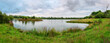 Panorama of Branton Lakes Nature Reserve, which was constructed from a former mineral quarry,...
#487096296
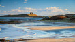 Low Newton Beach and Dunstanburgh Castle, part of the coastal section on the Northumberland 250, a...
#702290034
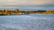 Warkworth Village viewed from the Harbour. Amble Harbour is actually called Warkworth Harbour and...
dodaj do ulubionych