

Zdjęcia na folii samoprzylepnej autora Peter Hermes Furian
FILTRUJ WYNIKI
Orientacja obrazów: wszystkie
pozioma
pionowa
kwadratowa
Rodzaj obrazów: wszystkie
zdjęcie
ilustracja
wektor
Zastosuj
#782995277
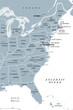 East Coast of the United States, gray political map. Also Eastern Seaboard, Atlantic Coast, and...
#795271483
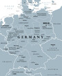 Germany, officially Federal Republic of Germany, gray political map. Country in Central Europe with...
#792777332
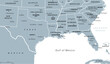 Gulf States of the United States, also called Gulf South or South Coast, political map. Coastline...
#756667558
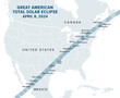 Great American Total Solar Eclipse, on April 8, 2024, political map. Major cities in the path of...
#792777487
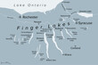 Finger Lakes region in New York State, United States, gray political map, with most important...
#813718299
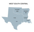 West South Central states, gray political map. United States Census division of the South region,...
#813718237
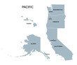 Pacific states, the West Coast of the United States, gray political map. United States Census...
#813718170
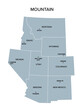 Mountain states, gray political map. United States Census division of the West region, consisting of...
#812519572
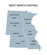 West North Central states, gray political map. United States Census division of the Midwest region...
#812519520
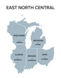 East North Central states, gray political map with borders and capitals. United States Census...
#812519470
 Hexagram shaped frame with wavy Flag of the United States pattern, alternately curved up and down....
#812519465
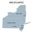 Mid-Atlantic, or Middle Atlantic states, gray political map, with capitals. United States Census...
#812519386
 Decorative border with wavy Flag of the United States pattern, alternately curved up and down....
#811718372
 Spiral triskelion with hollow triangle in the center. Triskele, ancient symbol and motif of a triple...
#811718336
 Spiral tetraskelion and quadruple spiral. Geometrical pattern and symbol of four conjoined two-armed...
#811718313
 Flag of the United States, curved up and down. The American flag, also known as The Stars and...
#809817973
 Geometrical pattern of four conjoined spirals. Tetraskelion or tetraskele, an ancient quadruple...
#809577632
 Emblem of the Trinity, three interlaced circles, an ancient Christian symbol, representing the union...
#809577604
 Triskelion, Neolithic triple-spiral symbol. Also known as triskele, an ancient motif of a triple...
#808937969
 Double-arm Archimedean spiral. An arithmetic spiral with two arms, connected at the center. E. g....
#808937936
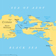
 Kerch Strait in Eastern Europe, gray political map. Narrow waterway that connects the Black Sea and...
#808937935
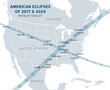
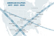 American Eclipses of 2017, 2023 and 2024, political map. Paths of the Annular Solar Eclipse of...
#808937875
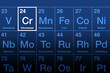 Chromium element on the periodic table. Transition metal, and chemical element with symbol Cr and...
#807787353
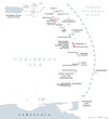 Volcanoes of the Caribbean islands, political map. Map of crescent-shaped island arc of Lesser...
#807787343
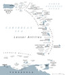 Eastern Caribbean islands, gray political map. Puerto Rico, Virgin Islands, Leeward and Windward...
#807787279
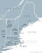 New England, a region of the United States, gray political map. Maine, Vermont, New Hampshire,...
#518149139
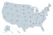 United States of America, gray political map. Fifty single states with their own geographic...
#811718221
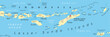 Lesser Sunda Islands, Indonesia, political map. Nusa Tenggara Islands, archipelago Southeast Asia....
#806892639
 Great American Eclipses, Paths of Totality, political map. Total Solar Eclipses of August 21, 2017,...
#806352184
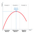 Law of diminishing returns. E.g. if you continually increase the amount of work on a constant arable...
#805968326
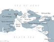
 Kerch Strait in Eastern Europe, political map. It connects the Black Sea and Sea of Azov, separating...
#805489681
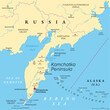 Kamchatka Peninsula, and the federal subject Kamchatka Krai of Russia, political map. Peninsula with...
dodaj do ulubionych